Posts tonen met het label wandelen. Alle posts tonen

maandag 27 mei 2013

Superstitious ? Me ?

After 2 years of preperations the starting date for The Great Outdoors Challenge 2013 was coming closer. The car had its MOT and was leaking oil, which was fixed. Parcels were send to Glen Nevis YH and Dalwhinnie Bunkhouse. According to Track&Trace the parcel to Glen Nevis YH arrived 4 days later on the 29th of April. The parcel to Dalwhinnie however had disappeared into a black hole in some depot in Inverness. The only thing I could do was to prepare another parcel and bring it to Dalwhinnie myself, prior to the Challenge.
Tuesday was a very warm day in The Netherlands, 24 C.. Before boarding police were checking cars with dogs, something I've never experienced before. After some delay the journey across the Northsea was very smooth although I didn't sleep well. I never do on such a trip.

Disembarking in Newcastle upon Tyne the next day was again delayed by stringent inspections from British customs. I received a text message from my wife saying she couldn't contact me. I tried to call home but a message from my provider said I didn't have enough credit left on my prepaid card. Ridiculous because I had raised my credit considerably before leaving home. Taking out and putting back in the battery solved that problem. I also switched on my Satmap 10 gps to let it know I was in the UK. It scared the hell out of me that it only showed the UK basemap. Again taking out and putting back in the batteries solved the problem and to my relieve I could use the 1:50k All of Britain map again. I followed the A1 north and a couple of minutes after passing the Scottish Border it started to rain. And it only stopped for 10 minutes in Dalwhinnie where I delivered my spare parcel and the sun was shining. Within 2 minutes after leaving Dalwhinnie and driving south on the A9 I was back in the downpour again. Around 6pm I collected my trainticket at Montrose Station for next day's journey to Mallaig before settling down at the South Links Holiday Park. I decided to keep the tent dry and payed for a night in a log cabine. I won't do that again. At three times the costs of pitching your tent you get no lighting in a cramped space, two small benches, a telly, central heating and not enough sleep. Traveling by train from Montrose to Glasgow Queen Steet Station was uneventfull. The Challenge hordes were gathering to continue their journey north to either Mallaig or Oban. I saw a lot of familiar (blog)faces.
Queen Street Station and...
...the gathering of the Clans.

The second half of the journey is far more interesting. You're entering the Highlands and the railway goes through some familiar and tremendous landscapes. The driver reduced speed so passengers could experience the Glenfinnan aquaduct intensely. In the sunshine because between Glasgow and Mallaig the sun was showing itself on a regular basis.
In Mallaig I'd booked a bed in the small but convenient Mallaig Backpackers Lodge. Outside I met Rolf Kerkhof Mogot, a fellow Dutchman, and Colin Tock, one of the famous vetters. We had diner together and with some other Challengers got lured into a quiz in the Clachain Inn. A second place and no prize as result. 
 
Mallaig harbour
Friday morning I signed out at the West Highland Hotel.  Despite being in the line of sight of a mast I couldn't get a signal on myphone. I still had it on roaming but I had to find a network manually. Vodafone didn't want me and O2 was too weak so T-Mobile it was. A last text message was sent home before venturing in the Rough Bounds of Knoydart where there is no reception at all. The battery of the Satmap gps had to be removed for the second time before being able to get a fixed position. This never happened at home.    
Knoydart Ferry at Mallaig Harbour
The sun was shining as the ferry docked at the quay. I opted for the 9.30 Knoydart Ferry instead of the 10.15 Bruce Watt Ferry because I needed every possible minute to accomplish my two planned Munros. Once on the boat clouds were pushing in and it started to rain. The cold wind made us move into the cabin. 40 minutes later we were dropped of at the pier of Inverie. In contrast with Challenge tradition I didn't visit the Old Forge, Britain's remotest pub on the mainland. Instead I turned left to start the climb on the track to Mam Uidhe. In the forest I was out of the wind and it felt warm and humid so I removed my Paramo jacket.    
Near the Mam Uidhe


First sight of Ladhar Bheinn


Once out of the forest and on the Mam Uidhe I can see Ladhar Bheinn, my first Munro of today, five kilometre as the crow flies. 2,5 km and 35 minutes after starting I arrived at the Folach turn-off. A pleasant track goes downhill into Gleann na Guiserein at an easy angle. One or two light showers

The Folach turn-off
Ladhar Bheinn looking fine


pass but there is no need to put on the jacket. Ladhar Bheinn is almost clear of clouds.
The ascent from Folach isn't the most interesting and commonly used as an easy descent route towards Inverie but the views from the ridge will be spectacular. Near the Folach footbridge a landrover is parked and beyond the old ruin an Akto has been pitched but there's no one around.
From the southeastern corner of the little forest it's a steady plod 2km northeast to reach the ridge near the little lochans. At first the angle of the grassy slope isn't steep but being my first hill in 3 years I still need to grasp my breath regularly. The inactivity caused by my lower backache a few weeks ago has apparantly lowered my degree of fitness considerably. Shortly after starting my ascent it starts to rain again, not hard but persistant. The slope gets significantly steeper and rockier for the last 500 meters beneath the ridge. A couple is coming down and the guy says the walking is good and not too windy. Although the cloudbase has lowered my direction is clear : 1,5 km SSE to reach the 1020m high summit of Ladhar Bheinn. To confirm this I check my Satmap. Shock and horror ! The device states it can't find it's internal memory ! Much to my releave I can still use the map itself which is on the SD-card. I've been studying my route for over 2 years so it's etched in my brain but it would be reassuring to see I'm still near the line on my map. The wind is strenghtening and the last 320m of ascent to reach the trigpoint is taking me longer than expected.

The Ladhar trigpoint
very close to the trigpoint
Suddenly its shape can be seen through the clouds, no more than 10m in front of me. A week ago this ridge was still snow-clad and impossible to walk without crampons and ice-axe and the snow is still alarmingly near. Today however it's the rain that's bothering me. Although not being in a downpour I can feel I'm getting wet inside my Paramo and my Goretex trousers. I'd washed them prior to the Challenge and reproofed them twice to be sure every inch would be rainproof. The same garment was 100% waterproof in a very wet and stormy Lairig Ghru 6 years ago. At 2.30pm  I reach the true summit at 1020m but don't linger near its cairn.
Ladhar Bheinn summit
 
I start my descend but what should have been an 'easy' walk down turns out to be much more difficult and slower than going up. The southeastern side of the hill is the usual way up and down for thousands of hillbaggers every year and the surface is very eroded and the rocks are polished by tens of thousands of boots. It's a nightmare to micro-navigate my way down and the steep scrambling bits, normally my favourite pastime, demand my full attention. Despite my care I slip several times.
The going is slow and by now I'm completely soaked. At this speed I won't be able to climb Luinne Bheinn and reach the River Carnach before 9pm. I'm getting an irrational feeling that 'something' doesn't want me here, too many 'incidents' have taken place and I feel I can't ignore these bad omens any longer. If I continue I'll be in danger and something really bad will happen to me.
I decide to go as far as the Mam Barrisdale and make my way down to Inverie. I recall Inverie having a bunkhouse where I would be able to book a bed and dry my cloths.
 
By now all the little knolls on the ridge feel like endless mountains whose summits disappear in the clouds. I'm releaved to reach the Bealach Coire Dhorrcail but the sight of the rough and steep and seemingly endless climb out of the bealach makes me feeling desparate.
The Mam Barrisdale is beyond my reach and I turn right at the bealach to go down Coire Torr an Asgaill and into Gleann na Guiserein. The terrain is tussocky and water is everywhere but I don't bother to look for dry spots. There aren't any and my leather boots are filled with water already so why bother ? Countless 'wee burns' have to be forded and one makes me fall over and I land on my side, half in the burn and half in the bog on the other side.
Gleann na Guiserein
Eventually I reach the LRT at Folach and I'm able to increase my walking speed. At 7pm I'm back in Inverie. 23km and 8,5hrs later and still at the same spot ! Now where is this bunkhouse ?

I walked passed the Old Forge and the last of the houses but saw no sign. After 500m I turned and walked back to Inverie. An old lady in a golfcart passed and when she returned I asked her for directions. I had to walk another 1km to the southeast for the Knoydart Foundation Bunkhouse.
A group was inside and said I had to look for the warden Anna in 'the house with the tractortires'.
She was very helpfull and said the bunkhouse was booked by a group and I had to ask them if I could stay for the night. I had seen a dryer in the bunkhouse and asked Anna permission to use it. She said that was okay. Back at the bunkhouse some members of the group didn't object sharing the bunkhouse with me but the leader of the group turned me down. I've never experienced such behaviour in the Highlands before and was amazed to say the least.
I went next door to the Knoydart Lodge B&B but they were fully booked also. My confidence in Highland hospitality was restored by Bob, the owner, who let this drowned backpacker inside and offered me tea immidiately and made some phonecalls to ask for availibility but everything was fully booked in Inverie. The Knoydart Foundation Ranger came in and said I could unofficially sleep in the logcabin on the beach. He also said there was also a peculiar woman with a trolley but I would get along with her just fine. I expressed my doubts about continuing my Challenge and Bob offered to bring me back to Mallaig with his own boat the next morning if I decided to stop. There's no ferryservice during the weekend : getting into Knoydart is easier than getting out.
Before going down to the beach I went back to the bunkhouse and stripped down to put all my wet cloths in the dryer. I wonder what the passing groupmembers where thinking of this halfnaked man in the hallway.
Unpacking my rucksack I discovered even my drybags had been letting in some water and, much more to my horror, my phone, which I had in a ziplockbag in the chestpocket of my Paramo, was wet.
Even my money was soaked. The only things that stayed perfectly dry were my Satmap, photocamera and print-outs of my routes. All had been put in Ortlieb mapcases.
45 minutes later I went to the logcabin and made myself  'comfortable' on one of the narrow benches. Some time later the 'trolleywoman', who turned out to be fellowchallenger Lindsay Jones, came in to prepare diner. She had postponed her start due to the bad weather.

By now I'd considered my options. Walking my lowlevel route to Sourlies and beyond seemed out of the question with even worse weather coming in and my phone out of order and not being able to contact Challenge Control on time. I would probably get soaked again without a chance to dry out.
I was still very strongly aware of nearby danger and the only thing I could think of was to go home as soon as possible. Lindsay tried to persuade me to continue but I had decided not to. She planned to go over to Barrisdale the next morning and when I asked her how she would cross burns with her trolley she replied she didn't know yet. I wished I had her optimism.
Lindsay retired to her tent and later that evening 6 young guys came in the logcabine to spend the night. Seven people sleeping in a 8 by 8 ft. logcabine makes you feel like sardines in a tin can. And I haven't mentioned the mice yet !

Saturdaymorning Bob ferried me back to Mallaig and by train I went to Fort William. I checked the timetable for my journey to Montrose the next day and discovered my watch had stopped 10 minutes earlier. Why ? I booked a bed at the Glen Nevis YH and asked for my parcel. It wasn't there.
I used the phone at the YH to contact the ferry company but of course they're not open in the weekend. I made a short call to Challenge Control saying I had withdrawn from the Challenge and last but not least an emotional phonecall home saying I would be returning home soon. On Sunday I returned to Montrose to call in at Challenge Control at the Park Hotel. John Manning was manning (pardon the pun) the desk and was busy answering incoming calls from Challengers. As I was there nr.7 and 8 reported their withdrawal and I learned that Lindsay J. was helicoptered out of the Mam Barrisdale the night before and another person was helicoptered out from Barrisdale. It must have been the Bermuda triangle.
Back at the Montrose campsite and my car I recharged my phone but sending one textmessage drained half the battery. Next morning I called the ferrycompany and got the answeringmachine saying "everybody was busy and I would be helped as soon as possible" (at 9am CET) . Then the music starts and my battery was drained. I plugged the phone into a socket and tried again. After 50 minutes someone at the ferrycompany felt sorry for me and answered the phone. I could get a ferry back to Holland the same day or a couple of days later. I left the campsite almost immidiately.
Driving past Edinburgh on the M9 my TomTom navigation indicated to stay on the righthandside lane for the A720 City Bypass. I've got an old TT and the situation has changed. I was driving towards Sterling and straight into an horrendous downpour. At the next junction I left the motorway and wanted to turn right at the end of the exit. Some cars passed in front of me coming from the right.
The road was clear, I pulled up and almost collided with a car coming from the right at high speed.
Something definitely wanted me out of Scotland, dead or alive.

Did I make the right decision ? I wasn't in immidiate danger and I've scrambled on knife-sharp ridges and stood on 2 inch wide ledges with a leathal drop beneath me in the past and I wasn't uncomfortable with that. Would something have happened to me if I pressed on ? Without the ability to go to a parallel universe I'll probably never know.

maandag 6 mei 2013

Final preparations

Tomorrow I'll be off to catch the ferry to Newcastle. Nervous ? Yes.
My backache is gone but I haven't carried a rucsac the last two weeks.
One parcel (Glen Nevis YH) has arrived, the other one (Dalwhinnie Bunkhouse) is still lost in space.
Looks like I'm going to have to buy some extra food and batteries and make a huge detour to deliver them myself prior to the Challenge. Thanks to the Royal Snail Mail.

The weather will be cool, wet and windy in the northwest and the Cairngorms are still extensively covered in snow. My route goes over the southern edge of the Cairngorms and the webcams near the Glenshee area (Cairnwell-Cairn Aosda-Glas Maol) don't show much snow. Perhaps I'll be lucky ?

Good luck to all Challengers and a safe crossing !

vrijdag 26 april 2013

Disaster strikes....almost

Last saturday I was writing down Challenge phonenumbers at the dinertable. As I stood up I realised I couldn't get my back straight up. Moving was difficult and painfull. I've had this lower backache in the past and more severe also but never at such an inconvenient moment.
In this state I wouldn't even be able to walk one kilometre, let alone from westcoast to eastcoast through Scotland.
Normally it would go away with time but time is the one thing I didn't have. Only 17 days before taking the ferry to Newcastle !
Yesterday I went to the physiotherapist and much to my relief things are going a bit better. Some more massages and I'll be up and running, ahum, walking again.   

vrijdag 19 april 2013

Pre-Challenge practice

I was able to get 2 days of work so I could do some proper training for the Challenge. Of course when I say 'proper training' I mean walking a reasonable distance on the flat instead of going up and down. There simply isn't much up and down in The Netherlands.

Last monday my wife drove me and the dogs to the nearest forest and kicked all of us out of the car. I left my wife, confusing the dogs whom to follow but after a couple of minutes of running back and forth they stayed with She Who Has To Be Obeyed. Traitors !

Bussumerheide
Two weeks ago the minimum night temperature was as low as     -10 C. but on sunday the max day temperature reached an incredible +23 C. At 8.45 am on monday it was already warm and feeling very humid. My rucsac contained most of the things I will be taking with me on this years Challenge.
A nice variation of wood and heath made for good progress in the morning.

Ancient neolithic burial hill - 4000 years old
At 11 am it started to rain but nothing serious. It was dry again at noon.
A nice and dry looking tree trunk looked like a suitable spot to have lunch. Ten minutes later a woman passed and asked if I hadn't been troubled by hornets. The treetrunk hosted a hornets' nest the previous year. Luckily for me there were none left.
great spot for lunch - a (former) hornets' nest
After going through more wood and some estate farmland I reached the former airforce base Soesterberg. This base has lost its function and buildings and runways are now being demolished to return the area to nature.
It also marked the end of walking in peace and solitude. The machines made a lot of noise and a busy A-road and motorway had to be circumnavigated.


German storage bunker from a 37mm Flak site
At 4 pm I reached my intended camping spot although it took me another half hour to locate the spot precisely. Wildcamping is illegal in Holland but there are some places where 'wildcamping' is permitted. This way of wildcamping is called 'paalkamperen', pole- or post camping. The only utility is a pump for pumping up groundwater by hand. The distance covered was 32 km.
'Paalkamperen' near austerlitz
At night the air was still and my Akto had considerable condensation on the flysheet.
I must admit it has been a long time since I slept in a small tent and I'm not as 'bendy' as I used to be.
The NeoAir Xlite airmattress was comfortable and didn't make much noise when turning from side to side. I also used an inflattable pillow, one with a hollow in the middle. It deflated a little during the night and that caused some necktrouble the next morning. A solution is needed before the start of the Challenge.
The forest had been full of singing birds the previous evening and the singing started again at the first sign of dawn. An early breakfast led to an early start at 7.30am. The route back home was slightly more to the west and 1km shorter making a total of 63 km in 2 days.
My feet felt good although the last 5km on tarmac wasn't too pleasant.

A beechlane, almost a mile long.


I had to go to work again on wednesday but felt wonderfully good and strenghtened.
Let's hope the infamous third Challenge day will be equally good.


donderdag 14 februari 2013

Snow. Again. And sleet....

...and rain, hail and icing and snow again. All with a bitterly cold, strong wind. And another 19km of walking. I feel stronger every day.
After walking in our local forest with my wife and our dogs she, and the dogs, drove home and I walked around the Naardermeer, a natural lake/swamp and Holland's first nature reserve, est.1901.

After a pinkish sunrise the sky was soon overcast. Snow was predicted at the end of the morning. It was a few degrees below zero but felt much colder.
The walk around the Naardermeer is called 'Het Laarzenpad' (The Wellies Way) because parts of it go through pastures and wet areas. The pastures are trodden by cows and were frozen solid. Crossing it for 1km was more difficult than walking on a Scottish boulderfield. 
At 11.30am it started with sleet which turned into snow 20 minutes later. The wind was coming from the side but didn't bother me too much. I was comfy in my Paramo Alta I jacket and Goretex trousers.
 
 
The lake was frozen and the howling wind made beautifull patterns on the ice. The last stretch I walked straight into the wind but I made good progress despite the difficult circumstances. I arrived home at 13.00pm covering 19km in 3hrs45mins.


vrijdag 31 augustus 2012

A beautifull summer. Really !


While it's raining cats and dogs, goldfish, rabbits, horses and even some elephants outside some will say it's been a bad summer. Sun lovers mostly. I don't agree. It has been wet while working and that doesn't count for me. Selfish, I know. While not working it has rained also but there's a major advantage : a lot of people stay inside so I've got the forest (almost) all for myself. Selfish again, I know. Last sunday me and the family went for a walk on the Veluwe. During the 65km drive it rained. Within 10 minutes from getting out of the car it stopped raining and the sun started shining. Lucky me.
The Zandenbos south of Nunspeet has a big advantage : dogs are allowed to walk freely. 
Or do some mudwrestling like our Tasmanian Muddevil.


He takes home several kilo's of sand but at least he's having fun. I was able to resist the mud - the wife wouldn't appreciate me joining the dog - but had fun nevertheless.
 
After an hour and a half we arrived at a little lochan. The sky was getting dark and we were just in time to put on our raincoats. The downpour lasted for five whole minutes during which five people huddled together underneath one umbrella. That's how I was able to take this picture without ruining the camera.
Tomorrow it's the first day of the meteorological autumn. Am I being selfish when wishing for changeable weather ? I don't see myself as 'ard but at least it keeps away the softies.

vrijdag 20 juli 2012

TGO Challenge 2007 day 9 : Derry Lodge - Braemar

I know, I know. 2007 is 5 years ago. I'd to rewrite my account after the previous host stopped hosting and republished that account earlier this year. You can read it at theooutdoors.
It thought it would be nice to create a 3D-fly-through using the Anquet OS maps. Problem is I'm a very busy man and it's a timeconsuming project so you'll have to be patient to be able to read the last day. I'll get there in the end.

donderdag 12 april 2012

Over the Hill Club Easter Meet 2012

Once again Suus and Bert had arranged the annual Dutch Challenge Reunion or Over the Hill Club Meet. A splendid get-together for British, Belgian and Dutch walkers to revive old memories, talk about the upcoming TGO challenge and to enjoy the Dutch countryside. This time the meet was held near Bennekom on the Veluwe.

I arrived friday afternoon in good spirit. Some had arrived earlier and more were arriving during the afternoon and in the evening. Our base was a Nivon hostel east from Bennekom.
Many hands helped to prepare an italian evening meal. I tried to grate a Pecorini cheese, the hardest cheese I've ever tried to grate. With help of Nicolas from Belgium I finally succeeded.
Buying the ingredients and cooking for 23 people isn't easy but it was a great succes.
The next day day Rolf had organised a walk from the hostel to the river Nederrijn following a former meltwater valley dating back to the ice-age. Two little streams flowing through this valley still contribute to the river Nederrijn. At one point most walkers crossed one of the burns by going over tree trunks and branches laid down in the stream. I waded straight through. It was only ankle deep ! During the Challenge they're prepaired to wade through much wider rivers thigh deep.
Rolf is an expert on the area we walked through - we even walked passed the house where he was born - and explained the legislative history to us. During the ice-age the originally north flowing rivers Rhine and Maas were forced by the icesheet to flow to the west. The icesheet formed moraines and after the ice retreated the wind deposited more sand on top thus creating a height difference of over 40m over a very small distance. Our British guests were impressed.
At one point the Romans created a path through the hillside to reach a rivercrossing. Nowadays there's a ferry at this point. We continued our walk through the river forelands on the north side of the river Nederrijn. At Wageningen most walkers did take the bus back to Bennekom. Only Nicolas, Paul and I walked back through the forest, a total distance of approximately 20km, arriving at the same time as the others. Much to their surprise. Our eveningmeal was an extensive Indonesian dish compiled by Rolf. Delicious.
On Easter Sunday we made a bicycletour. Some of our British friends aren't very experienced in cycling (on the wrong side of the road) but even Big John H. managed and I have to admit it has been a long time ago I did cover such a distance. The first part was through the same forests we walked yesterday only now we were on paved bicyclepaths and we were much faster. The ones in front were actually so fast they had to wait at regular interfalls for the ones behind. At one moment we waited for the last ones who had already passed. Doh ! This time we used the ferry to cross the river Nederrijn and followed the riverdyke west to Opheusden. Just before the next ferry we had a little stopover at 't Veerhuis for a drink and pie. Back on the north shore of the Nederrijn we visited nature reserve De Blaauwe Kamer, the site of a former brickfactory which was operative until 1975. The site was given back to nature.
Several times every year the area is flooded when waterlevel in the river is high thus creating an habitat for water loving animals and plants. You can watch a videocompilation on youtube here.
After De Blaauwe Kamer we continued are journey towards the southeastern point of The Utrechtse Heuvelrug, the western moraine. This point is called the Grebbeberg and was a vital point for the defence of Holland at the start of WWII. A little stream, initially flowing towards the river Nederrijn, had in the past been converted to a canal to be able to inundate the Gelderse valley between The Utrechtse Heuvelrug and The Veluwe. We followed this canal for a while before going east and north to reach The Veluwe again. We visited the Ginkelse Heath, the dropping and landing area for the Allied Forces during operation Market Garden in 1944. Today it was busy - within 100 yards of the parking - with Easter Sunday visitors.
After a short rest we biked to Natuurcentrum Veluwe. Here we had soup with bread and watched a video about wildlife on the Veluwe.

Shortly before sunset we walked to a hut for watching Red Deer. We saw a herd of hinds, soon disappearing between the trees, a red fox and two wild boars. In the dark we went back to the hostel arriving at 10 pm, having done a roundtrip of approximately 40km.

The last two days had been partly cloudy and dry but today the weatherforecast said showers and thubderstorms were expected. The programme was a mixed one. One group choose to go with Rolf to Arnhem to see the WWII infocentre, the John Frost Bridge etc. and a group choose to go to the Nationale Park De Hoge Veluwe with the Kroller-Muller Museum, Sculpture Garden and art deco hunting lodge St.Hubertus by architect Berlage. During the morning the rain was moderate but we were cosy in the museum. In the afternoon it was just light rain so we visited the sculpture garden.
I was walking with JD, Mairi and Suus but lost contact with them. They went with others to see the hunting lodge and I did a Dutch ridgewalk to another part of the sculpture garden.
At 4pm we called it a day and drove back to the hostel. The rain got heavier.

Once again a well organised meet with friends old and new. Many thanks to Suus and Bert for organising and to Rolf for the guided tours. Join us next year !

vrijdag 6 januari 2012

Former estate 'De Schaffelaar'

11 year old Cameron participates in a chess tournament in Barneveld today and I had a look beforehand for possibilities to walk the dog nearby. At the edge of Barneveld, in the province of Gelderland, lies former estate 'De Schaffelaar' (210 acres). The original castle was destroyed by the Spaniards in 1585 and a new house was erected. In 1767 the garden was created by a student of Andre le Notre, who designed the palace gardens of Versaille, and the house was rebuild and 33 year later destroyed by fire. In 1852 a new house was build in neo-Tudor style. Currently the house is now owned by the council of Barneveld and the gardens are in care of the 'Geldersch Landschap' society.  


Today was cold but calm and dry at last after several days of storms and rain. It's only 5 weeks ago that waterlevels in The Netherlands were so low that ships couldn't navigate properly on smaller rivers and even Rhine and Maas were difficult to navigate. However, waterlevels are so high at the moment that they had to open dykes in the northeast of The Netherlands to store excess water in polders. Excess water is normally pumped to sea but the lowwater level is too high to do so because of the northwesterly storm. People had to be evacuated.


zondag 6 november 2011

Autumn colours 2 and 3

It's exceptionally warm and dry for the time of year and not that many wind. The leaves are nevertheless falling rapidly at the moment. The first three pictures are taken a week ago, the last three today.
Oak leaves

All together now... 

Spanderswoud
Bantam

Schaep en Burgh

Alas, not my driveway (Schaep en Burgh) 

The Spanderswoud, Bantam and Schaep en Burgh are former estates between Bussum and 's Graveland. They are now owned by Natuurmonumenten en Goois Natuur Reservaat.


zondag 25 september 2011

Allt Duine windfarm threat

I have never been in the Monadhliath myself but I've seen them from other places. The Cairngorms for example. The wind turbines they want to build will be visible from many more places and the areas surrounding these metal giants will be destroyed.
Chris Townsend has recently revisited the area and has written an arcticle on his blog. If you love the wildness of Scotland you should read it and use the link for signing the petition.

In the Netherlands building projects can be delayed for years on end, or even stopped, with the use of a law protecting rare species of animals or plants. Isn't there such a law in Scotland ?  

vrijdag 12 augustus 2011

TGO Challenge 2007 day 7 : Kingussie-Rothiemurchus Forest

Pffff. Day 7 of my TGO Challenge is now online. It's easier to walk then to publish.


Phil at Doodlecat has asked me to republish the written account of my 2007 crossing. As you'll probably know the company that owns Fotopic has stopped their service and my story and all my Highlands and Islands pictures along with pictures of the ELD are no longer available online. I'm currently trying to locate my story on disfunctional computers. Once located I'll put it all back on t'internet using a new personal website. You'll just have to wait a little bit longer for that.

zondag 29 mei 2011

Avond4daagse : a daunder around town.

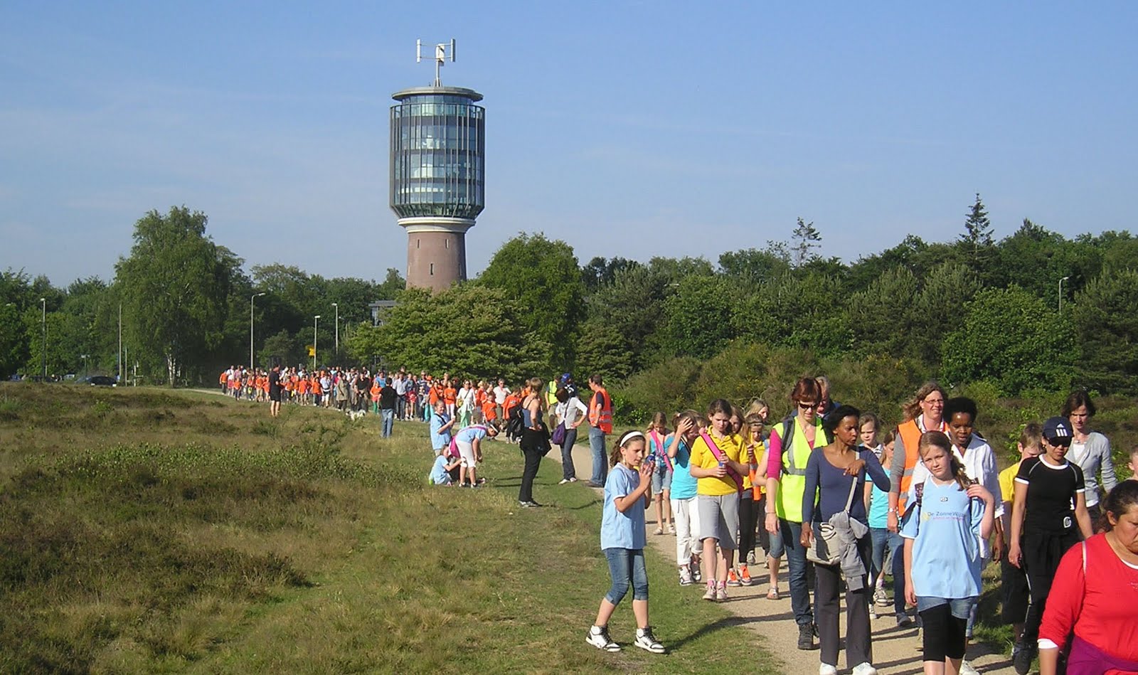
While some people were having fun swimming across Scotland from westcoast to eastcoast (has that been done already?) we did our annual "avond4daagse". The "avond4daagse" is a walk or daunder during 4 evenings in a row, mainly undertaken by schoolkids in the age of 6 to 12 but parents and anyone else can join also. Distances are 5, 10 or 15km and, like last year, there were approximately 1900 attenders.

We (me, my wife and kids aged 12, 10 and 6) always subscribe as individuals for the 5km. We don't like to walk with the schoolgroups for obvious reasons : too crowded, too much noise and very chaotic.

All walks start from the AW footballclub sportsground and go through the forest and heather of the district 'Het Gooi' in the Netherlands. These "avond4daagse" walks take place all around the Netherlands and have different starting points of course.

As you can see in the picture we had perfect weather for the first three days, contrary to the weather in most parts of Scotland. This drought has been going on for 8 weeks now. Only during the 4th evening there was some rain but, having started early, we finished before the rain started. The main groups got seriously wet though.